


Screenshot by Síle Moloney
Dynamic Star, LLC, the developers behind the first phase of the much-anticipated, two-phase, billion-dollar Fordham Landing Development in University Heights gave a presentation and update on the three-acre site to Bronx Community Board 7 (CB7) members on Feb. 11 at their monthly land use committee meeting.
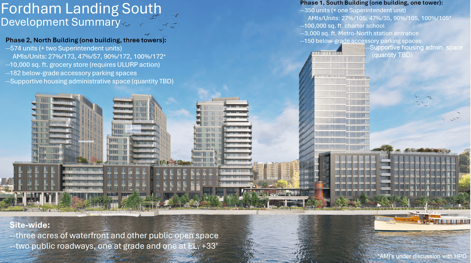
Brad Zachson, co-founder and director of development at Dynamic Star, said Fordham Landing South site, located at 320 West Fordham Road, is to be developed on a 4-acre site on the Harlem River waterfront and will be WELL-certified.

Screenshot by Síle Moloney
According to its website, “the WELL Building Standard™ version 2 (WELL v2™) is a vehicle for buildings and organizations to deliver more thoughtful and intentional spaces that enhance human health and well-being.”
Zachson said the site will include 924 affordable housing units, a 100,000 square-foot charter school, a 10,000 square-foot grocery store, a 3,000 square-foot University Heights Metro North station entrance, 330 below-grade accessory parking spaces, supportive housing administrative space, and three acres of public waterfront.
Source: Dynamic Star
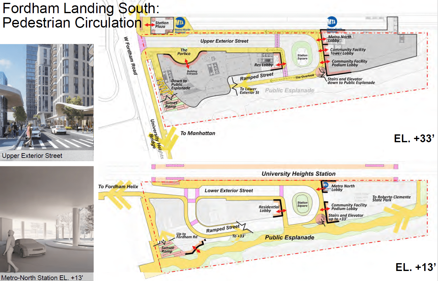
He said it will also include a two-level, internal public roadway full integrated into the New York City street network to provide access to the site, relieve traffic congestion, and facilitate bike access to the Harlem River Greenway.
Zachson went on to say that Fordham Landing South will consist of two buildings, separated by a 130-foot wide traffic circle and said the south building will be developed first as part of Phase I of the project. He said Phase I will consist of one building made up of one tower comprising 350 residential units, the charter school, the Metro North station entrance, 150 parking spaces and some supportive housing admin space.
Source: Dynamic Star
He said the north site would be developed as part of Phase II, which will consist of one building comprising three towers, 574 residential units, a grocery store, 182 parking spaces, and some supportive housing admin space. Zachson said two internal public roadways which will be integrated into the New York City street network will be accessible to pedestrians, bikes, scooters, trucks and cars.
Zachson said to access Fordham Landing South, a new curb will be cut along the south side of West Fordham Road to provide access from University Heights bridge, adding that conditional curb cut approval was received from NYC Department of Transportation (DOT) in December 2022. He said Dynamic Star was continuing to work with DOT to meet the necessary requirements before any Temporary Certificate of Occupancy could be granted for any of the housing units.
Source: Dynamic Star
He went on to say that the existing ramp leading down to Exterior Street on the north side of West Fordham Road will provide “grade level” access to the site.
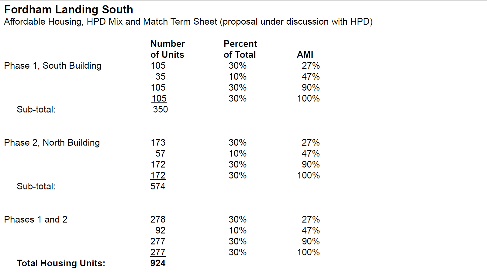
Meanwhile, details of the planned affordable housing unit breakdown as of Feb. 11 are also attached in a slide.
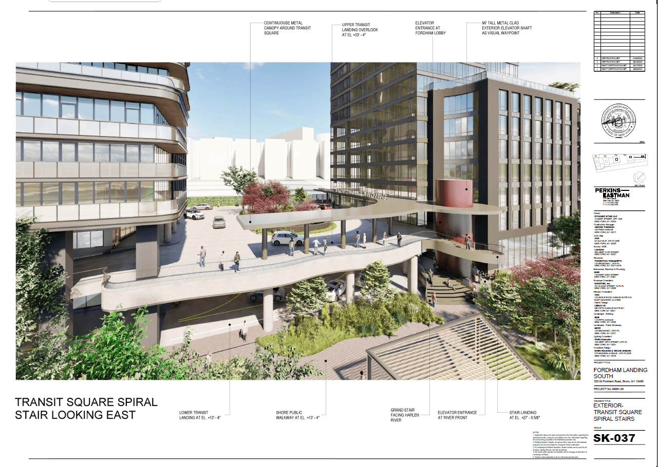
Zachson said three acres of waterfront and other public open space will also be provided at the Fordham Landing South site pursuant to Section 62-811(b) of the Zoning Resolution of the City of New York. He said the chair’s certification application for this space was approved by NYC Planning Commission Chair Dan Garodnick on April 11, 2024.
Source: Dynamic Star
Zachson went on to say that the planned public open space consists of a “grade level” shore public walkway along the Harlem River, a “grade level” path along University Heights Bridge, between the Harlem River and Exterior Street, a landscaped, ADA-compliant ramp near the site’s West Fordham Road entrance at an elevation of over 33 feet down to the grade level shore public walkway, and a circular stairs and elevator abutting the traffic circle, providing access to the grade level shore public walkway from an elevation of over 33 feet.
In construction, “grade” refers to the existing or finished ground level. Grading is the process of reshaping the land to achieve a desired elevation, slope, or a level surface for building or drainage.
In terms of sustainability, Zachson said that geothermal heat pumps would provide 60 percent of the building’s energy and the balance of the building’s energy needs will be sourced via high efficiency condensing boilers.

Source: Dynamic Star
He went on to explain that the “View Smart Window system” will use artificial intelligence to control heat and glare without the need for blinds, resulting in up to six-degree cooler interior temperatures on a hot summer day. He said energy recovery will be used for 100 percent of outside air systems, all appliances will be electric, even though the site is “grandfathered” to use natural gas, domestic hot water will be pre-heated with heat pump water return, exterior lighting will be Dark Sky-approved or equal, and will have controls to limit lighting with adequate daylight.
According to The Dark Sky website, the Dark Sky Approved program provides objective, third-party certification for products, designs, and completed projects that minimize glare, reduce light trespass, and do not pollute the night sky.

Image via Google Maps
Finally, to accommodate 2080 NYC Climate Resilience Design Guidelines, Zachson said the buildings are sited over 28 inches above the code minimum Base Flood Elevation of over 11 feet.
admin
Welcome to the Norwood News, a bi-weekly community newspaper that primarily serves the northwest Bronx communities of Norwood, Bedford Park, Fordham and University Heights. Through our Breaking Bronx blog, we focus on news and information for those neighborhoods, but aim to cover as much Bronx-related news as possible. Founded in 1988 by Mosholu Preservation Corporation, a not-for-profit affiliate of Montefiore Medical Center, the Norwood News began as a monthly and grew to a bi-weekly in 1994. In September 2003 the paper expanded to cover University Heights and now covers all the neighborhoods of Community District 7. The Norwood News exists to foster communication among citizens and organizations and to be a tool for neighborhood development efforts. The Norwood News runs the Bronx Youth Journalism Heard, a journalism training program for Bronx high school students. As you navigate this website, please let us know if you discover any glitches or if you have any suggestions. We’d love to hear from you. You can send e-mails to norwoodnews@norwoodnews.org or call us anytime (718) 324-4998.